Bariloche
Country: Argentina 🇦🇷
País: Argentina 🇦🇷
Страна: Аргентина 🇦🇷
Video VideoВидео
Overview
Bariloche is the main hub of Argentina’s Lake District and one of the most practical bases for exploring northern Patagonia.
The city combines good infrastructure with easy access to lakes, viewpoints, and mountains. Many highlights are reachable by public transport, making Bariloche suitable even without a car, while still rewarding longer stays.
Province: Río Negro
Base: Bariloche
Overall time: 7–10 days (can be extended)
Main focus: lakes, viewpoints, light hiking, scenic routes
Best season: October–April (winter is a separate ski-focused season)

Arrival & Bariloche City ▾
Arrive in Bariloche by flight (BRC) or long-distance bus.
From the airport:
• No regular city buses
• Limited long-distance buses (check timetable, book in advance)
• Taxi or pre-arranged transfer (often the simplest option)
Base:
• Bariloche town for the entire stay
What to do:
• Walk along the Lake Nahuel Huapi shoreline
• Visit small city beaches (Playa Centenario, Playa del Centro)
• Short walks to viewpoints above the city
This day works well as a relaxed start or buffer after travel.
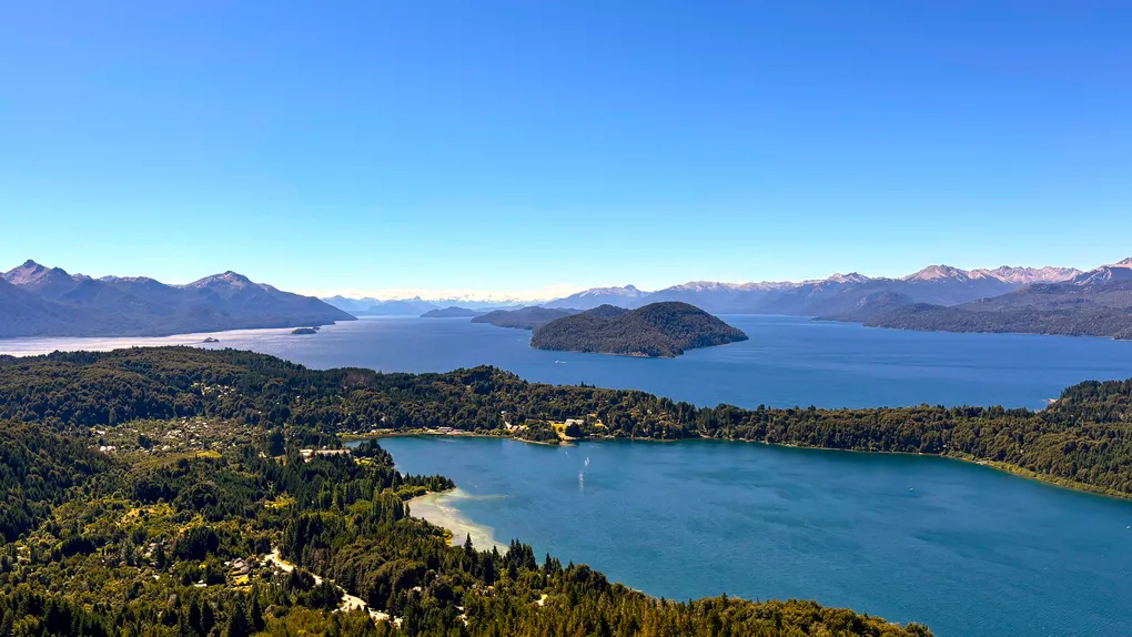
Cerro Campanario & Circuito Chico ▾
The easiest and most rewarding introduction to the Lake District.
Cerro Campanario:
• One of the best panoramic viewpoints in Patagonia
• Views over multiple lakes and surrounding peaks
• Accessible by chairlift or short uphill walk
Circuito Chico:
• Forests, lakes, peninsulas, and scenic viewpoints
• Several beaches suitable on warm, calm days
How to visit:
• Bus 20 (frequent and reliable) – best option for independent travel
• Taxi also works well
• Half-day tours cover main viewpoints efficiently
Duration:
• Half day to full day
Worth visiting even with mixed weather, but best on clear days.
Cerro Catedral (Weather-dependent) ▾
Cerro Catedral offers the widest mountain views near Bariloche.
What you see in summer:
• Panoramic views over Lake Nahuel Huapi
• Surrounding peaks and, on clear days, distant Cerro Tronador
• Alpine landscape at around 2000 m altitude
Access:
• Bus 55 (approximately every 2 hours; check timetable)
• Taxi or transfer (often easier for return)
Important:
• Only worth visiting on clear days
• Skip in fog or low cloud conditions
In winter, this area functions primarily as a ski resort.
Cerro Tronador & Ventisquero Negro ▾
A full-day mountain excursion to the highest peak in the region.
Highlights:
• Ventisquero Negro (Black Glacier)
• Volcanic landscapes and hanging glaciers
• Remote Andean scenery
Access:
• Rented car (best option)
• Organized day tour (practical without a car)
What to know:
• Long driving day
• Road conditions and visibility depend strongly on weather
Ruta de los Siete Lagos ▾
A scenic route connecting Bariloche with Villa La Angostura and San Martín de los Andes.
Highlights:
• Continuous lake and forest scenery
• Numerous informal stops and natural beaches
Options:
• Full-day return trip from Bariloche
• One-way trip with overnight stay in Villa La Angostura
• Continue to San Martín de los Andes (see related itinerary)
Access:
• Rented car strongly recommended
• Tours exist but allow limited flexibility
• Buses are a valid option, but do not stop at viewpoints
El Bolsón & Lago Puelo ▾
A quieter southern extension with a more rural atmosphere.
Highlights:
• Lago Puelo National Park
• The Arrayanes Forest
Access:
• Bus (frequent and reliable, ~2.5–3 hours)
• Rented car
Works well as:
• Long day trip
• Overnight extension
Optional Add-ons ▾
Colonia Suiza:
• Traditional stop along Circuito Chico
• More touristic than nature-focused
Isla Victoria & Bosque de Arrayanes:
• Boat excursion on Lake Nahuel Huapi
• Scenic but expensive
• Landscapes similar to Circuito Chico
Andean Crossing to Chile:
• Bariloche → Puerto Varas (boat + bus)
• Exceptional volcano views
• Expensive and requires at least 2 days
Cerro Otto:
• Closest viewpoint to the city
• Ski center in winter, viewpoints in summer
Transportation
- Car is useful but not required
- Bus 20: Circuito Chico & Cerro Campanario (very frequent)
- Bus 55: Cerro Catedral (every ~2 hours)
- Taxis are practical for viewpoints and flexible timing
Connections
- Bariloche → San Martín de los Andes (Ruta de los Siete Lagos)
- Bariloche → Esquel (bus, ~5 hours)
- Bariloche → Mendoza (by flight)
- Bariloche → Puerto Varas (Chile, multi-day crossing)
Useful information
- Nahuel Huapi National Park (maps, fees):
https://www.argentina.gob.ar/parquesnacionales/nahuelhuapi - Bariloche public transport information:
https://mibus.com.ar - Official Bariloche tourism site:
https://www.barilocheturismo.gob.ar
Notes
- Weather can change quickly; plan mountain days flexibly
- Views depend strongly on visibility
- One of the most practical long-stay bases in Argentina